
» Aardenburg
» Abbey of Ter Doest
» Adegem
» Bruges
» Castle of Middelburg
» Donk
» Dudzele
» Fort of Bavaria
» Knokke-Heist
» Koolkerke
» Lissewege
» Maldegem
» Male
» Middelburg
» Oedelem
» Sint-Anna-Ter-Muiden
» Sluis

 |
Koolkerke
 The
name "Coolkercke" was mentioned for the first time in 1243, but
the village already existed a while before. This settlement
came into existence in the 12th century on the place where the
road to the abbey of Ter Doest
crossed the Soete Vaart. At the highest point, around 1150, the
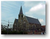
first church was built. The present church is a protected
monument and dates back to 1860, with parts out of the 14th
century. The
name "Coolkercke" was mentioned for the first time in 1243, but
the village already existed a while before. This settlement
came into existence in the 12th century on the place where the
road to the abbey of Ter Doest
crossed the Soete Vaart. At the highest point, around 1150, the
first church was built. The present church is a protected
monument and dates back to 1860, with parts out of the 14th
century.
 Where
does the name "Koolskerke" originate from? The highest place
where the church was built was called "Kool" or "Ten Kole". The
patron saint of the church was St.-Niklaas (St.-Nicolas), also
called "St.-Kool". But, couldn't there be another explanation?
This village was namely founded by a certain Nicolaas Gaillaerd,
who also ordered the construction of the church. The village
was at first known as "Cool-Gailliaerds kercke" (so, the "church
of Nicolaas Gaillaerd", because Cool has the same meaning as
Nicolas), lateron this name changed into Coolkercke and
Koolkerke. The fact that the patron saint was St.-Nicolas
maybee is a sign of medieval modesty of the founder. Let's
leave this one to the experts. Where
does the name "Koolskerke" originate from? The highest place
where the church was built was called "Kool" or "Ten Kole". The
patron saint of the church was St.-Niklaas (St.-Nicolas), also
called "St.-Kool". But, couldn't there be another explanation?
This village was namely founded by a certain Nicolaas Gaillaerd,
who also ordered the construction of the church. The village
was at first known as "Cool-Gailliaerds kercke" (so, the "church
of Nicolaas Gaillaerd", because Cool has the same meaning as
Nicolas), lateron this name changed into Coolkercke and
Koolkerke. The fact that the patron saint was St.-Nicolas
maybee is a sign of medieval modesty of the founder. Let's
leave this one to the experts.
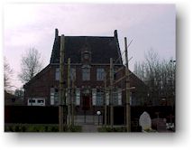
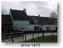 Opposite
the church's entrance stands the 19th century presbytery,
somewhat further down the road stands an old farm with the year
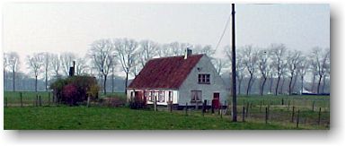
1673 on the facade. On the main road to Bruges, on your right
hand, you can see another old farm. On the other side of that
road lies the fortress of Bavaria. Opposite
the church's entrance stands the 19th century presbytery,
somewhat further down the road stands an old farm with the year
1673 on the facade. On the main road to Bruges, on your right
hand, you can see another old farm. On the other side of that
road lies the fortress of Bavaria.
Koolkerke is
situated at about 5 km from
Damme, in the direction of Bruges, on the westside of the
Damse Vaart. The fortress of Bavaria (fort van Beieren) is
situated between the Damse Vaart and the church of Koolkerke.
Worth seeing:
church, presbytery, some old farms,
fortress of Bavaria
 |


|