
» Aardenburg
» Abbey of Ter Doest
» Adegem
» Bruges
» Castle of Middelburg
» Donk
» Dudzele
» Fort of Bavaria
» Knokke-Heist
» Koolkerke
» Lissewege
» Maldegem
» Male
» Middelburg
» Oedelem
» Sint-Anna-Ter-Muiden
» Sluis

 |
Dudzele
 There
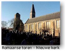
is something remarkable about Dudzele: the village has 2 church
towers. One church but two towers. You needn't be an
acheologist to see that the tower that stands alone is the older
one. That tower is built in Romanesque style and dates back to
the 12th century. The actual church was only built in 1871;
parts of it still originate from the 17th century. The
Romanesque tower was in fact not the real church tower of
Dudzele's old and dissapeared church. No, he was just one of
the corner towers. It must have been a pretty large church.
She was constructed between 1150 and 1200 and torn down in
1634. But why did they leave this one tower standing? In the
16th century the church was plundered; just like most of the
villages and towns in Flanders, Dudzele fell pray to the
destructive Geuzen (protestant religious warriors). Besides the
entry of the church stands a chapel in Neogothic style in
remembrance of the casualties of World War I. There
is something remarkable about Dudzele: the village has 2 church
towers. One church but two towers. You needn't be an
acheologist to see that the tower that stands alone is the older
one. That tower is built in Romanesque style and dates back to
the 12th century. The actual church was only built in 1871;
parts of it still originate from the 17th century. The
Romanesque tower was in fact not the real church tower of
Dudzele's old and dissapeared church. No, he was just one of
the corner towers. It must have been a pretty large church.
She was constructed between 1150 and 1200 and torn down in
1634. But why did they leave this one tower standing? In the
16th century the church was plundered; just like most of the
villages and towns in Flanders, Dudzele fell pray to the
destructive Geuzen (protestant religious warriors). Besides the
entry of the church stands a chapel in Neogothic style in
remembrance of the casualties of World War I.
 Dudzele
is old, in 704 a domain (called Dudece) was given as a gift to
the St.-Pieters abbey of Ghent. Several 'military'
constructions stood in the vecinity of the village center such
as: Schottencastle, manor Hof van Grammez, the castle of
Dudzele, castle Pathoeke and fortress Pathoeke. There isn't
much left of it. You'd think that foreign armies in the Middle
Ages are to blame for this. Not quite. Not too far from the
center, in the direction of
Lissewege, lies a canal: the Boudewijncanal. This stream
connects
Bruges with Zeebruges and for the excavations, a large part
of Dudzele's territory had to be expropriated. Pathoeke castle,
fortress Pathoeke and a number of farms were in the way and were
lost forever... Dudzele
is old, in 704 a domain (called Dudece) was given as a gift to
the St.-Pieters abbey of Ghent. Several 'military'
constructions stood in the vecinity of the village center such
as: Schottencastle, manor Hof van Grammez, the castle of
Dudzele, castle Pathoeke and fortress Pathoeke. There isn't
much left of it. You'd think that foreign armies in the Middle
Ages are to blame for this. Not quite. Not too far from the
center, in the direction of
Lissewege, lies a canal: the Boudewijncanal. This stream
connects
Bruges with Zeebruges and for the excavations, a large part
of Dudzele's territory had to be expropriated. Pathoeke castle,
fortress Pathoeke and a number of farms were in the way and were
lost forever...
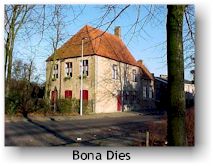
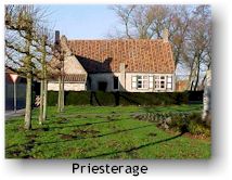 A
number of pretty houses ornament the center of the village such
as the old 'smisse' (forge) next to the church. On the other
side of the church you can see a few houses from the 17th
century which are called Pronckenburgh, Bona Dies and
Priesterage. The last one stands next to a small park in which
you can find the statue of Amaat Vyncke. A
number of pretty houses ornament the center of the village such
as the old 'smisse' (forge) next to the church. On the other
side of the church you can see a few houses from the 17th
century which are called Pronckenburgh, Bona Dies and
Priesterage. The last one stands next to a small park in which
you can find the statue of Amaat Vyncke.
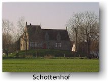
A bit further, on the outskirts of the village stands the
Schottenhof. In the facade stands the number 1639. This house
is a nice example of how people used to build and how villages
came into existence in an age when the land was largely
inaccessible and inundated regularly. It stands namely on what
is called a 'terp' and is surrounded by a ditch. A 'terp' is
actually a piece of higher land on which the shepherds could
safely retreat in case of need (especially when there was a
flood). These 'terps' were lateron connected to eachother by
small dikes, which created villages which in their turn were
connected again to eachother with small dikes. 'Zele' has the
same meaning as 'terp'. So we could say that Dudzele was the
'terp' of a farmer called Duda.
 To
reach Dudzele, you only need 5 minutes by car from the center of
Damme. Starting from the
market square of Damme, you cross the Damse Vaart and a bit
furtheron, you only have to follow the signs. Don't forget to
enjoy the beautiful polder landscape. If you continue a bit
further, you will end up in
Lissewege. To
reach Dudzele, you only need 5 minutes by car from the center of
Damme. Starting from the
market square of Damme, you cross the Damse Vaart and a bit
furtheron, you only have to follow the signs. Don't forget to
enjoy the beautiful polder landscape. If you continue a bit
further, you will end up in
Lissewege.
|


|