|
» Lapscheure church » Ruins first church » Blue sluice » Fortress St.-Donaas » Old road sign » Ferry Kobus » Platte Kreek » Damse Vaart » Agricultural museum » Damme town walls » Damse Vaart » NR Fortress Saint Donaas » NR The Zwin » Sluis |
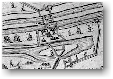
Fortress Saint Donaas
In 1568 the 80-year war started between Spain and the Northern Netherlands. When in 1604, prince Maurits of Nassau took the towns of Sluis and Aardenburg, the town of Damme found itself in the frontline of the battle. As a consequence, numerous fortifications were raised on both sides of the front. The most notorious fortification was the bastion of Saint Donaas. Other fortresses in the area were amongst others the Frederikfort, fort Saint Job, fort Isabella and lateron (between 1615 and 1620) also the star-shaped town walls of Damme. This line of forts was also called the line of Cantelmo. Shortly after the capture of the town of Sluis by the army of the Northern Netherlands, the Spanish commandor Spinalo ordered the construction of the fortress of Saint Donaas as a kind of counter-fort against Sluis. This fort also enabled the Spanish to supervise the navigation between Sluis and Bruges (via the canals "Soete Vaart" and "Soute Vaart"). During the Spanish Successionwar (1701 - 1714) the fortress was extended but it would not serve its military purpose for much longer. The fortification was levelled for the most part when the Damse Vaart was dug. All that remains now of the fort, is located at the northern side of the Damse Vaart and has been transformed into a nature reserve (see NR Oud Fort Sint-Donaas").
|
|
 Location: Damse Vaart Noord (at
the landing-stage of ferry Kobus), 8340 Lapscheure [gps]
Location: Damse Vaart Noord (at
the landing-stage of ferry Kobus), 8340 Lapscheure [gps]